|
|
The largest park in Randolph is the Blue Hills, and the largest water body is Ponkapoag Pond.
You could walk from thousands of homes in Randolph into the Blue Hills, and picnic or swim at Ponkapoag Pond.
But few people in Randolph know about these recreational resources because they have such limited access.
We have an opportunity right now to open up Ponkapoag Pond to Randolph -- our one chance for many years to come!
The state is planning a
multimillion-dollar improvement project (download 180 Mb PDF) around Ponkapoag Pond in Randolph, Canton and Milton.
There's going to be a
public input session on Dec. 8, 2021, to finalize what to improve.
Jesse and Kathleen describe here the current plans, and how we can get a lot more for Randolph if we come and speak.
The session is run by the DCR, the Commonwealth's Department of Conservation & Recreation, who manage our state parks.
DCR is not so good at listening -- we only get this one chance to get heard, on Dec. 8, so you have to come to that virtual meeting.
The Town Council gets another non-public meeting on Nov. 30, so you can write to the Town Council in advance if you can't attend on Dec. 8.
Jesse and Kathleen suggest focus on just three goals (so that DCR can hear the people of Randolph with a unified voice):
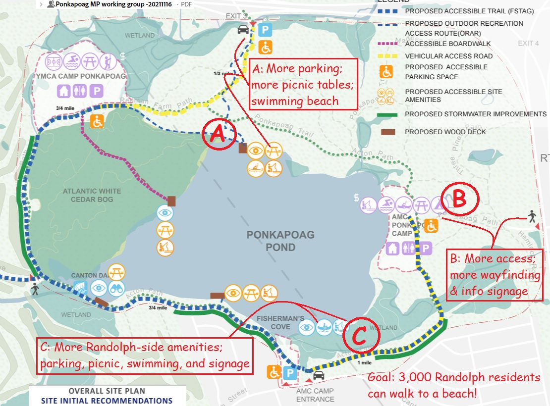
- A. More access from Exit 3 on I-93
There's a YMCA Camp on the Canton-Randolph border north of Ponkapoag Pond, accessible from Exit 3 on the interstate.
- Boston students can attend the YMCA Camp for free -- how about a camp where Randolph students can attend for free?
- There's parking for a dozen cars there -- how about a hundred cars, like at Houghton's Pond in Milton?
- DCR also plans one (1) picnic table along the "Outdoor Recreation Access Route (ORAR)" -- how about dozens, like at Houghton's Pond?
- DCR plans a "Wood Deck" on Randolph's shore -- how about a lifeguarded sandy beach, like at Houghton's Pond?
- B. More access to AMC Camp :
There are a couple dozen cabins in the woods in Randolph, called the "AMC Camp", run by the Appalachian Mountain Club.
You can rent a cabin there to go camping, and anyone can walk to the AMC swimming area -- but it's hard to find.
You COULD walk there from the Donovan School -- but it needs better "wayfinding signs" for the mile-long "Ponkapoag Path".
And there are 4 or 5 more access points from the Deer Park neighborhood -- if we maintained those "right-of-way" and trails.
- C. More access from Canton Street :
Fisherman's Cove, off Randolph Street in Canton, currently has only boat access -- let's ask for swimming and picnic areas too.
We could extend the current area eastward into Randolph, and expand from just boat access to a full beach....
- How about a sidewalk from Canton Street and Randolph Street to the Fisherman's Cove entrance, so people can safely walk?
- How about clearing the "right-of-way" entrances from Deer Park (4 of them on Sunset Drive) for pedestrian access?
- How about a small parking area on "Hemlock Road" walking trail (past the dead end of Turner Drive in Deer Park)?
3,000 residents of Randolph and Canton live within easy walking distance (in Deer Park, Avalon Drive and nearby) -- and could walk to the beach!
Jesse will propose all three of those goals at the Dec. 8 meeting. You can add your ideas, or other ideas, at that meeting.
Some of Jesse and Kathleen's other plans appear below too -- beyond the "study area" of the current Ponkapoag Pond map, which ends at Route 24.
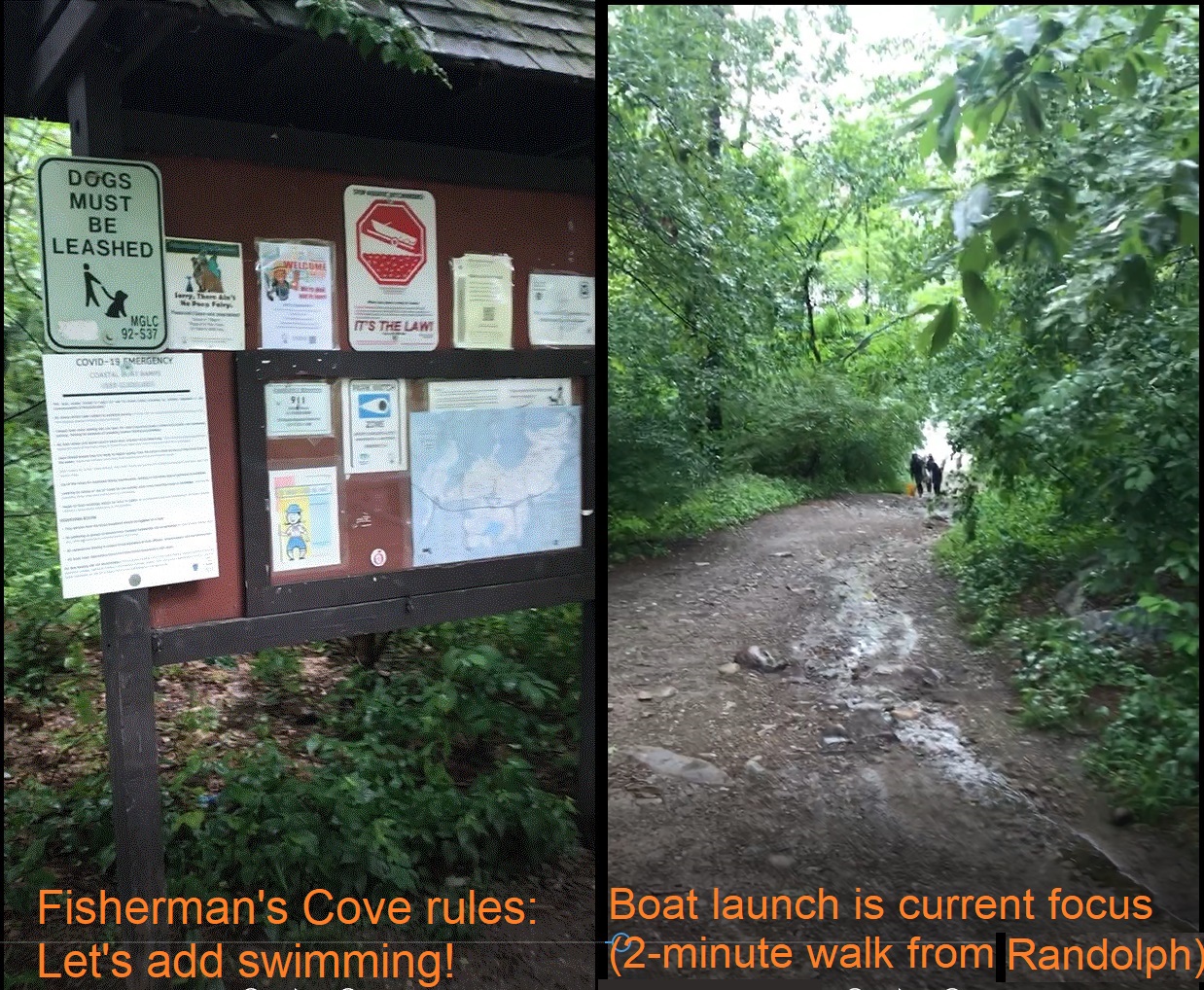
Fisherman's Cove Boat Launch
Part of "Point C": Click photo for YouTube video, or click here for enlarged photo.
This entrance to Ponkapoag Pond is designed for boaters -- but could be redesigned for swimmers and picnickers and families!
There's already a parking area, but most people are un aware of it -- let's improve the signage!
And the cleared area could be extended eastward into Randolph, to create a "Randolph-Canton Beach".
The DCR is already considering extending westward to the dam -- but the goal should be a lifeguarded sandy beach just like at Houghton's Pond.
DCR points out that eastward to Randolph is a wetland -- but Jesse notes that Houghton's beach has a stream running right through the middle of the beach (it's a wetland too).
2024 update: The DCR accepted SOME of these plans (notes below), but need to hear from YOU to make it happen!
|
 |
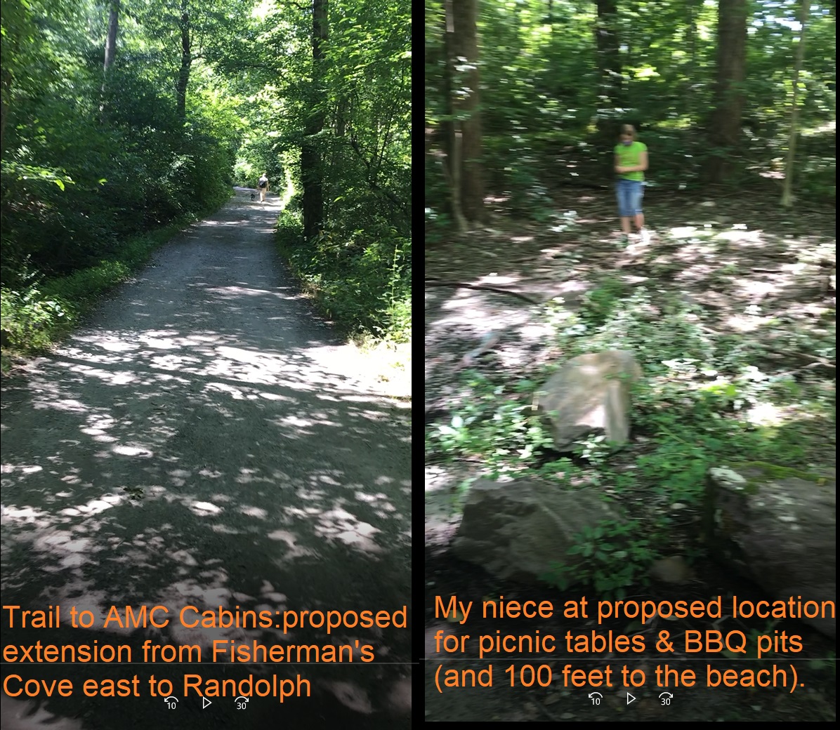 |
Randolph-Canton Beach walking distance to 3,000 people
Part of "Point C": Click photo for YouTube video, or click here for enlarged photo.
This video shows the proposed location for the beach extending from Fisherman's Cove eastward to Randolph.
(The beach could also extend westward to the dam in Canton -- so maybe a good name is "Randolph-Canton Beach").
The video is all in Randolph -- and all very near Ponkapoag Pond -- but you can't tell because it's heavily wooded.
From this spot, you CAN see the pond (not readily visible in the video because of the heavy woods).
From the next video, you CAN see some local streets in Randolph too -- there really are thousands of people who could walk to this beach from their homes!
When you talk to people from Sharon about what's nice about living in Sharon, they say, "Oh, we have the beach" (that's Massapoag Lake) -- we should be able to say that same thing in Randolph!
2024 update: No new "Randolph Beach" but DCR agreed to allow swimming at both Fisherman's Cove and the AMC Cabins.
|
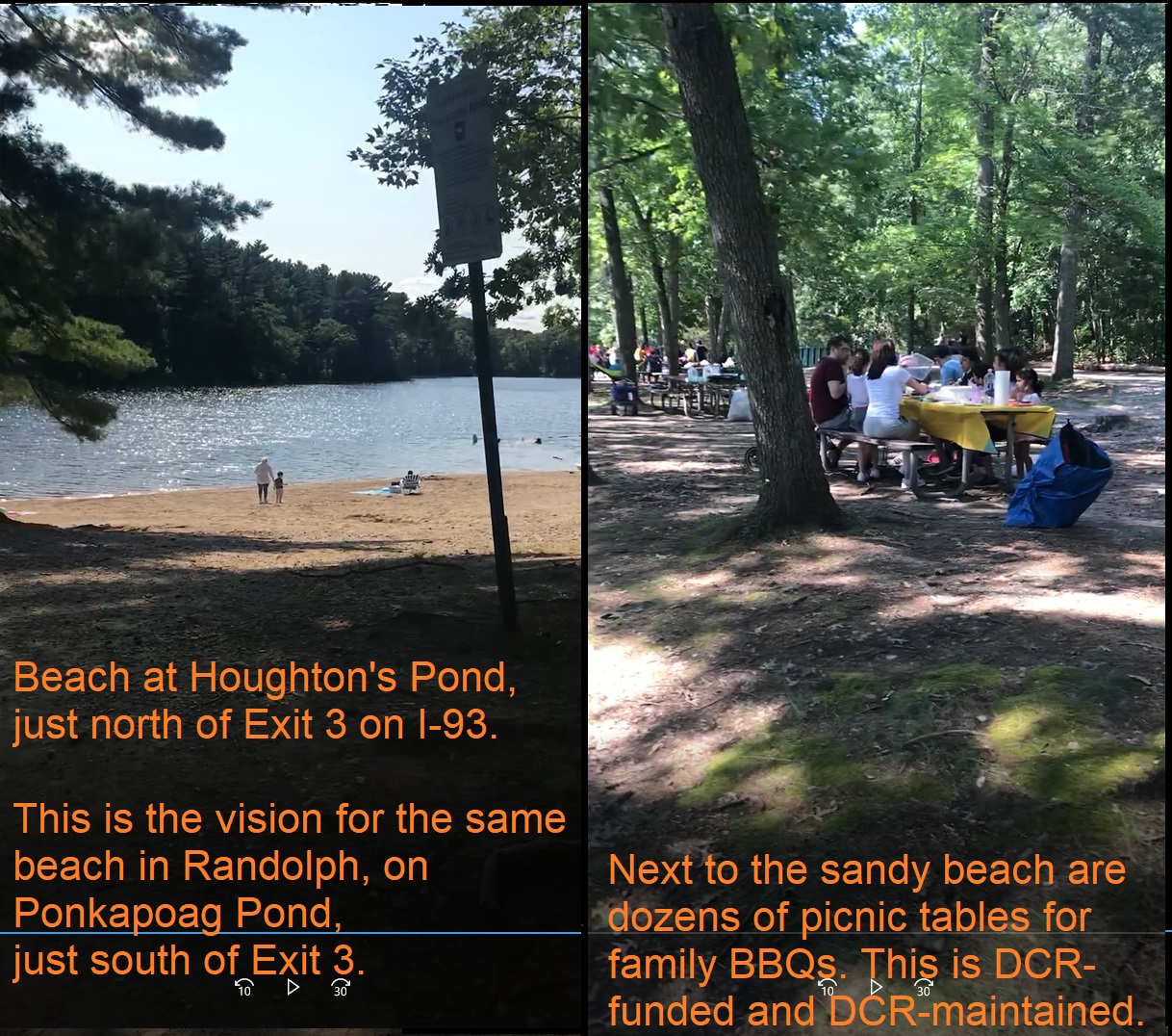
Family Picnic area in Randolph like in Milton
Part of "Point A": Click photo for YouTube video, or click here for enlarged photo.
Take a trip to Houghton's Pond Beach in Milton -- also in the Blue Hills -- the state DCR maintains and runs a lifeguarded sandy beach there, with hundreds of parking spots.
On any summer weekend, families speaking a dozen languages enjoy a family picnic or BBQ at the beach, as shown in the video on one summer weekend.
Why do the people of Milton have this wonderful recreational resource, while the much bigger pond in Randolph is surrounded by mostly just woods?
Because decades ago, the people of Milton asked, while the people of Randolph have been ignored for all those decades.
Wouldn't it be great to have a beach like this in Randolph, which thousands of our residents could walk to, and all of our residents could enjoy?
This is our one chance for the next several decades to get a Randolph Beach!
2024 update: DCR has accepted the concept that the people of Randolph are entitled to a public beach that isn't hidden from the public. But what exactly money gets spent on, that's still an open question....
|
 |
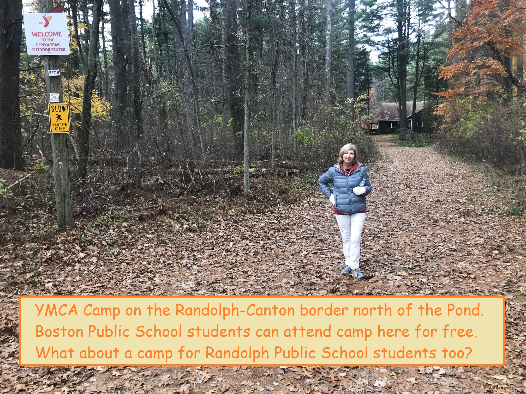 |
YMCA Camp at Canton-Randolph border
Part of "Point A": Click photo for YouTube video, or click here for enlarged photo.
The Massachusetts DCR will rehab this YMCA Camp -- but it is only for Boston Public School students.
Maybe some amenities could be built on the Randolph side, like a planned new parking lot and a new "pavilion,"
so Randolph Public School students could go there for free like BPS students.
Alternatively, RPS students could have a new camp at either the
Randolph-Milton Beach area, or the Randolph-Canton Beach area.
2024 update: Millions are allocated to rehab the YMCA Camp. No plans for Randolph attendees.
|
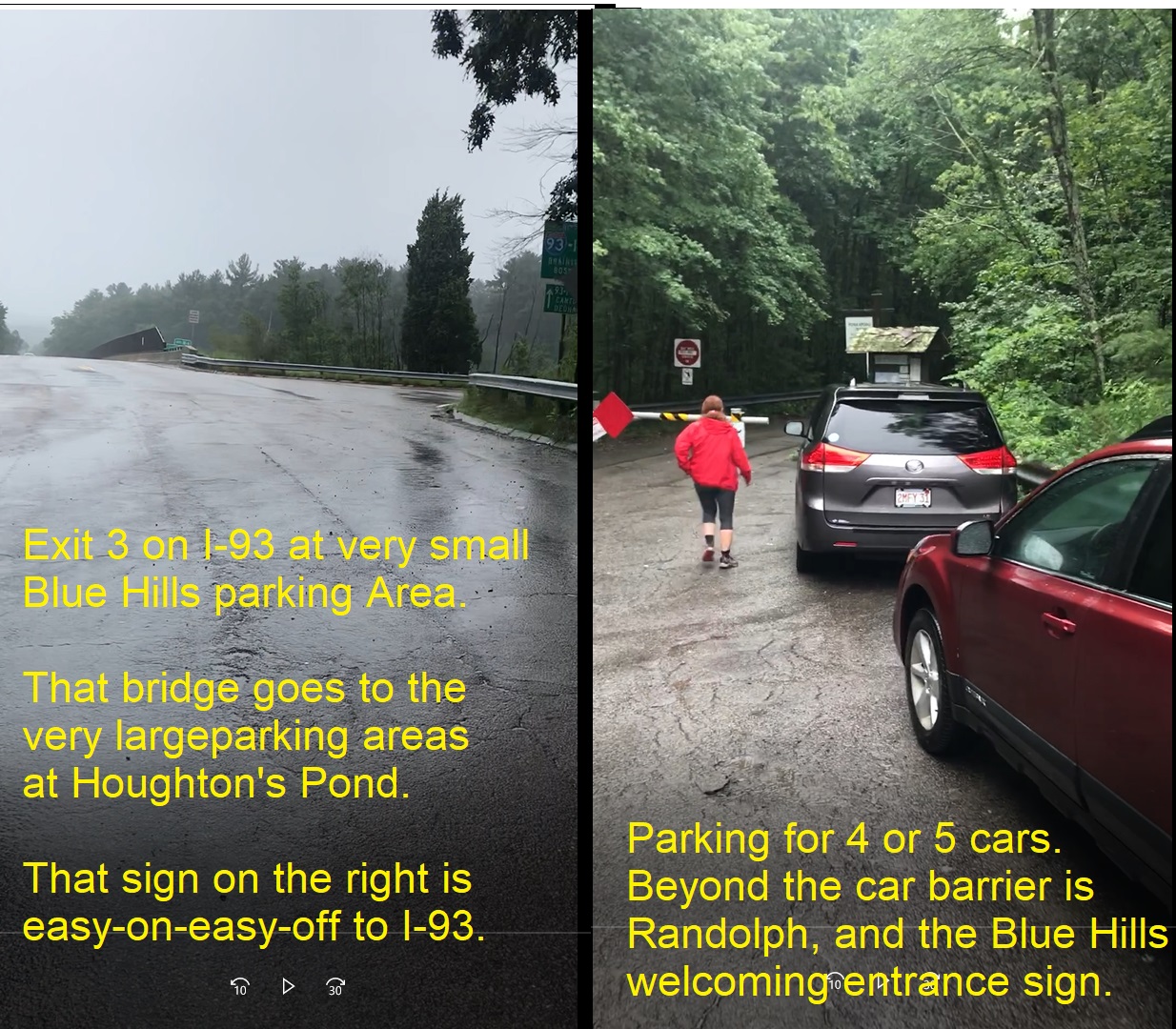
Exit 3 and Randolph-Milton beach access
Part of "Point A": Click photo for YouTube video, or click here for enlarged photo.
From Exit 3 on Interstate 93 in Milton, the Massachusetts DCR is planning to build through Randolph an Outdoor Recreation Access Route (an improved road) to the YMCA Camp in Canton.
Jesse and Kathleen propose to include 100 parking spots for the public (not just the YMCA); dozens of picnic areas (not just the one planned by DCR now); and a fully-lifeguarded sandy beach (not just a wooden deck as currently planned).
The Randolph-Milton beach area would not interfere with the YMCA Camp nor any other amenities -- it's all open woods.
Exit 3 on I-93 could be access for people who could choose to go north to Houghton's Pond or south to Ponkapoag Pond.
This could also be the location of the Randolph Summer Camp for the schoolkids of Randolph (details in YMCA section).
2024 update: DCR plans include Exit 3 with more parking (not 100) and some picnic tables, but no beach and no sand.
|
 |
 |
Randolph-Canton Beach access for local residents
Part of "Point B": Click photo for YouTube video, or click here for enlarged photo.
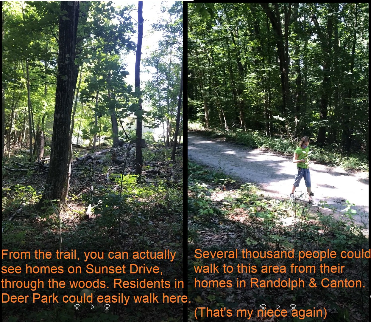
The North Randolph neighborhood of Deer Park is nestled in the Blue Hills, and comes within 100 feet of the Ponkapoag Pond trail. But there's no access.
There are 5 access points available -- one on a named hiking trail called Hemlock Road, which is the pedestrian-only continuation of Turner Drive.
The other 4 access points are one "right-of-way" at each street ending on Sunset Drive.
A "right-of-way" means the town owns the empty land between homes, and only has to clear the bursh and put up signs to allow access.
Jesse and Kathleen propose opening all 5 access points, and adding signage that motoroists can park elsewhere but hikers and bicyclists are welcome.
In addition, the Ponkapoag Path crosses Rt. 24 and then heads for the AMC Camp -- maintaining that trail too would allow hiking access from the rest of North Randolph (see Donovan School for more).
2024 update: Jesse and Kathleen did Friends of the Blue Hills "Adopt-a-Trail" adopting all of these trails, but DCR agreed only to signs to the existing entrances.
|
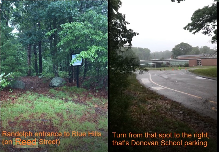
Donovan School access to Blue Hills
Part of "Point B": Click photo for YouTube video, or click here for enlarged photo.
You know those woods at the back of the Donovan School parking lot on Reed Street where it meets Canton Street? That's the Blue Hills!
If you hike on the trail there, it crosses the "Fire Bridge" or "Horse Bridge" across Rt. 24, and then you walk a half-mile on Ponkapoag Path and you end up at the AMC Camp.
I first did that hike with my son 15 years ago, and later took all of his friends on the same hike -- their reaction was always something like, "Waitaminit -- this means I can WALK from my house to this lake?!"
People born and raised in Randolph -- and even people whose kids attend the Donovan School -- are often unaware that this beautiful lake is so nearby.
That's because the signs are terrible -- the only Blue Hills sign is hidden in the trees on Reed Street (not where people enter the trail from the Donovan parking lot).
And the signs and trail once you cross Rt 24 are barely existent -- I get lost there even after hiking there for 15 years!
The DCR project can fix these "wayfinding" signage problems and make real access to the AMC Camp for the people of Randolph.
2024 update: The Randolph Community Preservation Commission paid for a wayfinding sign now installed at the back of the Donovan School parking lot.
|
 |
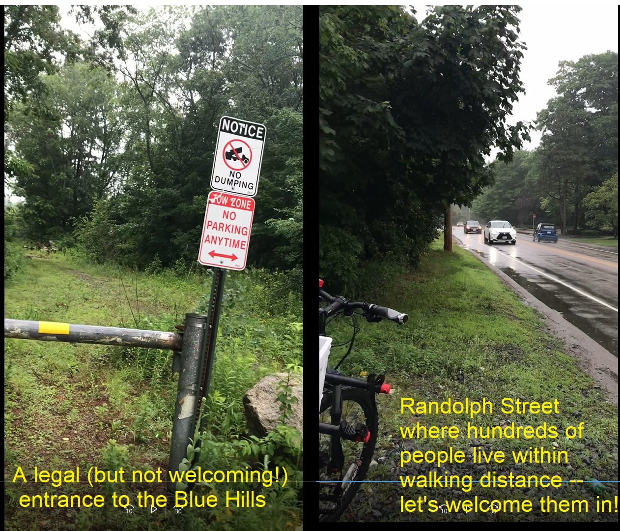 |
Ponkapoag Pond entrance off Randolph Street in Canton
Part of "Point B": Click photo for YouTube video, or click here for enlarged photo.
This is a legal entrance to the Blue Hills State Park, but it's hard to tell -- there are signs cautioning against entry and dumping, but no sign welcoming parking or hiking. This could be a series of entry points for hiking around Ponkapoag Pond, with small parking areas for a few cars, and a map "You are here." You can see in this video a hiker's car parked at this entrance -- plus my bicycle -- I think it's legal to walk in or bike in!
Other possible entry points are:
- the abandoned North Randolph Little League field on High Street;
- the locked gate at Middle Street off High Street;
- the dead-end at Billings Street of Scanlon Drive (behind Lantana)
- the dead-end of Turner Drive in Deer Park;
- the Donovan School on Reed Street.
Take a drive up Rt 28 in Quincy and you'll see lots of small parking areas for a few cars, and a map "You are here" at some of them.
People use every one of those for Blue Hills hiking and we could do the same!
2024 update: The Randolph Community Preservation Commission paid for a wayfinding sign now installed at the baseball field on High Street, and the Randolph DPW sometimes maintains the area.
|
|