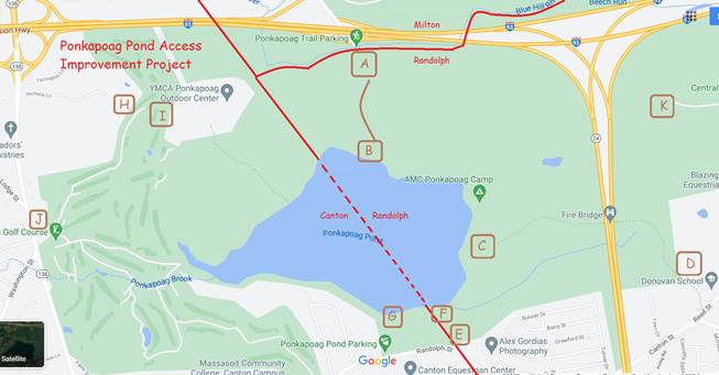
A. Ponkapoag Trail Parking (exit 3) has only a few parking spots and pavement stops at the Randolph border; could build more parking spots like near Houghton's Pond.
B. Walking trail from Ponkapoag Trail Parking to the pond's circumnavigation trail needs signage and trail improvement -- google map doesn't even show it as a trail (marked with a brown curve; it IS there, but hard to find).
C. The trail from the Fire Bridge to the pond peters out on google map -- and on the ground! Needs signage and a lot of trail improvement so it's marked and findable going east.
D. At east end of Fire Bridge trail is Donovan School -- it does have signage at the school, but needs "improvement" (and Town Council definitions of who can park there for hiking purposes!) -- this is the most expensive item since it's a long trail (about a mile).
E. There is a parking area on the south of the pond, labeled "Ponkapoag Pond Parking" on google maps -- but it's in Canton and we need the same in Randolph. At point "E" could be a new entrance to a parking area from Canton Street right on the Randolph-Canton border. There are several pedestrian right-of-way corridors from Sunset Drive too.
F and G. There's a maintained beach at point G in Canton -- I'd love to see the same thing as point F in Randolph. The beach is lovely but it's in Canton and Randolph residents are generally unaware of it (and it's not marked in a welcoming manner). Both points serve as parking areas and as entry points to the circumnavigation trail.
H. There is an unmarked trail here, from Homan's Lane into the Blue Hills, that needs signage and trail improvement. It's unclear what the intent is -- how are hikers and bicyclists supposed to get through to the trail that leads from the YMCA to the circumnavigation trail?
I. One must cross a golf "green" to get from the unmarked trail to the paved golf course path. I do that by bicycle but golfers then use me for target practice -- I think a discussion with the golf course is needed to clarify the intent, and then add signage accordingly. There IS good signage where the circumnavigation trail crosses the golf course.
J. Additional clarification is needed for parking rules in Rt 138 golf course parking lot. Something like a sign saying "park here for trailhead; walk this route through golf course to pond." And a big-picture map with "You are here", to be repeated at every other point above!
K. Point "K" is an abandoned missile silo from the 1950s -- see https://www.youtube.com/watch?v=2cs9obYuQZ4 -- which has a paved path through to Randolph streets (it's a blocked road called "Middle Street"). It could serve as another entry point to the trail system, but the missile siloes present a unique cleanup aspect (i.e. very expensive).
-- Jesse Gordon, Randolph District 2 Town Councilor, (617) 320-6989, jgordon@randolph-ma.gov