|
"Environmental Justice" means that the people of Randolph have access to the land and water resources of Randolph. For too long, parts of Randolph have been closed to the public for state projects or federal projects -- that isn't right! The solution is more "open access" -- more welcoming signage; more pedestrian and bicycle and MBTA access; and more Town Council pushing for state and federal resources.
In 2022, we passed a "PFAS Testing Resolution" jointly in Randolph and Holbrook,and MassDEP did some PFAS testing and found some clues about our reservoir's high PFAS levels. But the TLA Trash Transfer Station never did any testing, so the Holbrook Conservation Commission denied their construction permit in July 2023. Click for all the details and what comes next; here's a summary: WayfindingHow do we make Randolph more welcoming for newcomers? We need more signs, pointing between our existing parks! For example, the north end of the Dog Park trail is only a hundred yards from the south end of the entrance to the Powers Farm boardwalk -- there should be signs saying so, at both ends! Adding signs is called "Wayfinding." It's an important tool to make Randolph more accessible for pedestrians and bicyclists. If you're out on bikes with your kids, wouldn't it be great if THEY could find the route to a nearby park? That applies to newcomers to town also -- better wayfinding makes Randolph more attractive and more welcoming. If you've lived near the Reservoir for years, sure, you know the entryways to the paths around the water -- but there should be signs so the rest of us can find them too! This video shows a "wayfinding" project in which Jesse participated in Cambridge. He was bicycling with his son around the Alewife Red Line T station one day, when another dad and son asked "How do we bike to the Charles River?" Jesse showed them the way, but realized that there should be signs SHOWING the way, so anyone could do the same. Jesse worked with the Cambridge Bicycle Committee and the Cambridge Pedestrian Committee to get a bunch of signs posted around Alewife station -- pointing the way to the river, to Somerville, to Belmont, and to other destinations, and providing the distance so newcomers could plan their trips. Jesse gives a little tour of the Alewife "Minuteman Trail Extension" in this video, showing some of the signs for which he wrote the text, and helped get posted. These signs aren't brilliant literature -- they say things like "Charles River 2.7 miles (18 min.)". But getting them posted makes it so that a dad on his bicycle with his kid can come out of the T and see where to go!
This sort of Wayfinding is exactly what we need in Randolph. Some examples are:
That last item, signs at Powers Farm, is the subject of Jesse's proposal to the Community Preservatoin Commission, Aug. 5, 2019
Randolph once had a train station: the Old Colony Line ran from Boston to New York City. There�s a monument on Depot Street, near that new Chipotle�s restaurant, where the train depot used to stand; the abandoned track then runs along North Street and Teed Drive. We can use that land as a �Rail Trail.� A Rail Trail means that bicycles and pedestrians can travel along the old railroad right-of-way � which are always relatively flat and straight. Randolph�s Old Colony Line runs to Braintree Station to the north, and to Avon and beyond to the south. Rail trails elsewhere in Massachusetts are extremely popular. For example, the �Minuteman Bikeway,� which runs 12 miles from Somerville to Bedford, serves thousands of commuters per day, by foot and bike and skateboard and anything else non-motorized. Politicians from those communities worked hard to get that rail trail opened to the public � I would like to work to open up a long rail trail in Randolph. There�s a little bit of the Old Colony Rail Trail open to the public � from Depot Street through Belcher Park to North Street, about a half mile. The right-of-way extends alongside two cemeteries to beyond the Teed Drive industrial park � that whole section could be used as a rail trail just by clearing the brush and maintaining it. There�s also a connection from Belcher Park to the new Community Center � through the DPW maintenance lot near the Amvets Hall. You can see it from Belcher Park, and if your boots and your balance are good, you can walk down a steep embankment and get to the Community Center. All that�s needed there are some welcoming signs instead of the warning notices currently posted, and maybe a staircase. Those sorts of improvements � and so many more � can be done for hardly any money. And when more money is needed for bigger projects, the Commonwealth and private rail trail organizations routinely provide funding. A lack of money isn�t what has stopped the Old Colony Rail Trail � it�s a lack of political will, and the people of Randolph are left with less than their fair share. Further details in newspaper article: Make Community Center Part of the Community, Aug. 10, 2017
Before Interstate-93 was built in 1957, Randolph had a road directly into the Blue Hills � Middle Street, off of High Street near Scanlon Drive. That street was cut by the federal government; a U.S. Army site on Middle Street was demolished; and a �No Trespassing� sign now adorns the entrance from High Street. Braintree had a similar road cut by Interstate-93: off of West St in Braintree, near Brooks Drive and Forbes Road just past the Randolph Reservoir. Go take a look at that road � it�s paved for about a half-mile, great for bicycling or skateboarding, and then a hiking trail beyond that. It has a sign telling about the trails, and a picnic table near a parking area so you feel welcome. How come Braintree gets those amenities and Randolph doesn�t? Because Braintrree�s politicians ASKED for them. I am unafraid to ask for our fair share. I see past the �No Trespassing� signs and see what COULD be available to the public, and I know how to ask the Commonwealth to fund those projects. Think what Randolph could have: First, a biking and hiking trail like Brantree has. A nice place to take the kids for a picnic and then hike into the woods. Or a safe paved road without any cars, where you can teach your kids to ride a bike. Second, at the end of Middle Street, the abandoned U.S. Army site has a big paved parking lot in the middle of the woods � the sort of place that kids would envision as a �skate park.� Skate parks have obstacles and curved surfaces for skateboarders and adventuresome bicyclists � several towns in Massachusetts have them, but there are none in Randolph. I'm not sure what the right use of that land is, but I AM sure that Randolph should have access to it! It�s time for Randolph to get our fair share. Six decades ago, the Interstate cut off a piece of Randolph. The federal government never cleaned up their mess � let�s claim it back for the people of Randolph. Randolph�s reservoir is shared with Holbrook and Braintree, but is mostly in Randolph. It is the largest water body in Randolph, but it is closed to the public, surrounded by attack dogs and �No Trespassing� signs. How come? �Oh, we need to keep people away from our water supply,� say the establishment politicians. We do? Many towns in Massachusetts use the land around their reservoirs for recreational purposes � Randolph could too. When politicians keep �people� away, that means keeping US away from using OUR land. Take a look at the Fresh Pond Reservoir, on the Belmont-Cambridge border. It has a 3.5-mile �multi-use� trail around its entire perimeter, with a dog park at one end and a golf course at the other end, and picnic areas all around. The people of Belmont and Cambridge enjoy the dozens of acres, and the lovely view of the reservoir itself (there�s a fence between the perimeter trail and the water). Why can�t the people of Randolph have that? Take a look at the entrances to the Randolph reservoir. You can get there from King Hill Road in Braintree � there�s a warning sign on both ends that you�re trespassing on tri-town land (that�s OUR three towns, so it�s OUR land!). If you go beyond that warning, as you approach the water treatment plant, additional signs warn of attack dogs. Compare that to the Fresh Pond Reservoir�s water treatment plant, where schoolkids go on organized tours to learn how water treatment plants works. I want to change our reservoir land from �No Trespassing� zones into educational zones and recreational zones. Further details in newspaper article: Gordon would push to open closed rec areas, Sept. 29, 2017
The Blue Hills Reservation spans six towns: Randolph, Milton, Quincy, Canton, Dedham, and Braintree. Randolph has by far the fewest amenities of the six towns, despite our large share of its acreage (Randolph�s area extends past Ponkapoag Pond to Exit 3 on Interstate 93 � that�s all ours!) Look at the other towns� amenities: Milton has a Blue Hills Museum and a popular lake beach; Quincy has miles of hiking trails used by thousands of hikers; Canton has a golf course, a ski area, and a boardwalk on their part of Ponkapoag Pond. Even Braintree � with far less Blue Hills acreage than Randolph � has a marked hiking trail � while Randolph does not. But when I asked some members of the Blue Hills Hiking Club whether their hikes ever extended into Randolph, they looked at me quizzically, saying �How could we?� because it�s so hard to get to. Go take a look on any summer weekend at the beachfront on Houghton�s Pond � you�ll find families gathering around barbecue pits and people enjoying recreational facilities around the lake. Randolph has MORE lakefront on Ponkapoag Pond than there is for Houghton�s Pond � Ponkapoag is a much larger lake, but it is much less developed. How come? We could WALK from many parts of Randolph to Ponkapoag, if there were a place to walk to. We can fix that! Randolph DOES have access to the Blue Hills, of course � it�s just not publicized like it is in every other town. You can get to the Blue Hills by parking at the Donovan School � those woods alongside their parking lot lead to the Horse Bridge, which leads to Ponkapoag Pond. But there�s only a half-hidden small sign there. And there are no signs at the High Street entrance (used as a bus repair depot) or the Middle Street entrance (closed to the public with �No Trespassing� signs). Compare that to Milton, which has a dozen trailheads marked along Rt. 138, with several parking areas. Compare that to Quincy, whch enjoys the economic benefits of hundreds of hikers ending the day at the Quincy end of the Blue Hills trails. Compare that to Canton, which has welcoming maps of the Blue Hills Reservation along Randolph Street. Even Braintree has a Welcome sign, for their little tiny bit of acreage of Blue Hills near Forbes Road. But Randolph barely acknowledges that we�re part of the Blue Hills at all. How come?
I envision Randolph getting our fair share of the Blue Hills: developing Ponkapoag Pond like Houghton's Pond has been developed. Doing so would bring revenue to Randolph, and would also give our families a new gathering center within walking or biking distance from much of Randolph.
Holbrook is planning a new �transfer station� where garbage comes in by truck, gets compacted, and goes out by truck � through Randolph. Holbrook gets the economic benefit of the transfer station, and Randolph gets the garbage trucks on our streets. How come? There�s a term for this sort of political failure: �environmental injustice.� That term was coined in the 1970s when a church group studied every negative environmental amenity (like transfer stations) in the United States, by zip code. The richer the people in the zip code, the fewer negative environmental amenities they had. Hard-working middle-class towns, communities of color, and towns with high immigrant populations � towns like Randolph � had far more negative environmental amenities. THAT is why we get the garbage trucks on our streets � it�s just another example of environmental injustice. Randolph has been suffering from environmental injustice for decades. There IS a way to get environmental justice for Randolph � elect politicians who understand that the people of Randolph deserve their fair share, and have not been getting it. If elected, I will fight to bring environmental justice to Randolph. Environmental injustice isn�t the only injustice. The same political failure that affects Randolph�s environment also causes political injustice (we�re poorly represented in the State House); and economic injustice (wealthy towns get MORE money to build schools than Randolph gets!). We need new politicians who will fight to get Randolph our fair share. Vote for Jesse Gordon. Further details in newspaper article: Help Randolph fight environmental injustice of Holbrook trash facility, June 23, 2019 UPDATE June 2023: How David stopped Goliath: The Holbrook ConComm denied an extension of the TLA building permit based on PFAS! UPDATE August 2023: How to clean up PFAS: Subcommitee meeting at Randolph Town Hall August 17 at 5:30 PM -- please come or download the PFAS cleanup info sheet with plans for DPW and ConComm!
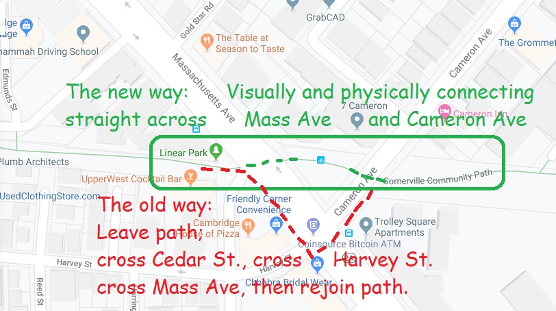
How do we get from Powers Farm to the Dog Park? From Belcher Park to the Community Center? From North Randolph to Ponkapoag Pond? All of those are walkable, and all could be part of a "connect-the-dots" project across Randolph. This video shows one such "connectivity" project in which Jesse Gordon participated in Cambridge and Somerville -- visually "connecting" a pedestrian walkway from one side of Mass Ave (Route 2A) to the other side.
|
|||||||||||
| >
Home > About | | ||||||||||||