Boardwalk and Park Place: Open park access
Randolph has many lovely parks and conservation areas -- but we're not allowed in!
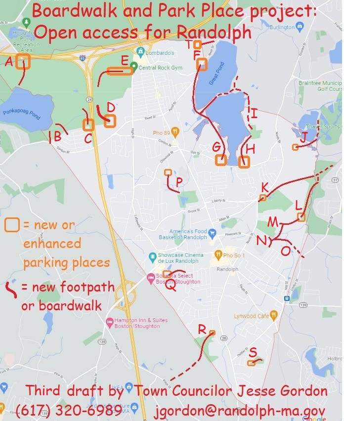
This project opens access to our existing parks, creating access points by foot or by car, for 21 existing park locations around Randolph (detailed below). There are no proposed new land purchases and no new designations of park areas -- we have already invested in these parks, and now we should allow ourselves to enjoy them!
The map to the right proposes "boardwalks" shown in red. These boardwalks would be like the existing popular boardwalks at Powers Farm -- raised wooden walking paths in swampy or difficult-to-access areas. In some cases ground-level footpaths are all that's needed, and sometimes only new signs are needed.
For example, point "Q" is a swampy area between the Bittersweet Lane apartment complex and the Post Office across from the theater on Mazzeo Drive. That's only a few hundred yards distance -- it could be a walking route for thousands of residents to those businesses. But it's a swampy area so no one walks through it -- instead it's a 2-mile walk to the High School and back.
Sometimes all that's needed is a place to park your car [shown as orange boxes]. Creating parking places in or near our existing parks means more people can use them, for their kids or for recreation or just to enjoy the outdoors. A model for a small parking area is Soule Park off of Grove Lane -- just three parking spots, but from there, you can walk to Norroway Pond.
For an example of where parking places are needed, look at point "S", which is the South Randolph Conservation Area. Even people who live adjacent don't use it, because the only signs say "No Dumping". What if the signs instead said "Park here and welcome to walk in"?
This proposal fulfills important "Open Space and Recreation" goals of the Randolph Master Plan: (p. 5 of 218, and goals 5/6/7 on page 102, and OSR4/OSR5/OSR6 on p.204-5)
- Connect and improve existing conservation lands with greenways and multi-use trails to
provide public access for all residents.
- Provide and maintain recreational lands and facilities for active and passive use as to include
and address the needs of all ages and abilities of Randolph's population and demographics.
- Maintain municipal parks and open spaces at a sufficient level.
- Disperse recreation facilities including parks, sports fields, and community properties
throughout the Town.
This proposal also addresses important aspects of the Community Wellness Plan:
- "Certain parts of Randolph were underserved by open space, especially parks suitable for active use.... Few focus group participants mentioned the Blue Hills Reservation as a community asset, and it was generally not mentioned in focus group discussions. Whether the omission was due to a lack of access or knowledge of the Blue Hills Reservation requires further investigation." (p. 17 of 137)
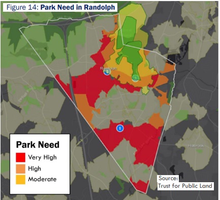
- "Figure 14 [below] shows that 53.7% of Randolph residents are within a 10-minute walk of a
park. 14,128 residents have limited park access." (p. 18 of 137)
Boardwalk and Park Place: Open park access
Description of each proposed Boardwalk and/or Parking Place:
- A. Exit 3 on Interstate 93: Already a parking area here; I proposed to DCR to expand it as part of Ponkapoag Pond project and they likely will do so. The Town could add our own signage linking to other Randolph access points.
- B. The Town has several "right-of-way" access points into the Blue Hills State Park (town land off Sunset Drive). I proposed to DCR opening these for pedestrians -- it's our responsibility on the Town side.
- C. At the end of Turner Drive is a right-of-way that leads directly to a DCR hiking trail. We could add signs and a path to that hiking trail, and create a few parking spots. I proposed this to DCR too, but it's unlikely they'll participate.
- D. The Donovan School has a hiking trail entrance at the back of the parking lot (off of Reed Street). There's a sign on Reed Street but none in the parking lot -- we could define parking rules and add signs.
- E. There's a street called "Middle Street" off High Street, which is closed by DCR with a gate. The street extends several hundred yards to the abandoned missile site but also to several hiking trails. The entire street could be opened as a parking area.
- F. The north end of the Reservoir Walk (off Pond Street) has a few parking spots, but needs signs so people know that it's legal. And some signs indicating hiking destinations (including a hidden workout area near this spot!)
- G. There's another workout area off of Oak Street that has no parking. Let's add a few spots so people can use this, It also leads to a the same Reservoir Walk trail, but needs signs because it's hidden.
- H. Off Oak Street on the east side of the reservoir is another section of the Reservoir Walk, with some parking spots that look like they're illegal. Needs signs saying what's legal and encouraging hiking.
- I. The Fin-Fur-Feather conservation area is hidden in the woods -- it needs signage welcoming in pedestrians, including hidden entrances on Isabell Circle and State Street. I've discussed with Braintree residents and representatives continuing the Reservoir Walk on their side -- it's very rough but you CAN walk around!
- J. The Richardi Reservoir spans the Randolph-Braintree border like the main reservoir does -- and it could also have a Reservoir Walk. Possible entry points include Meadow Lane, Lincoln Ave, and Randolph Road -- some right-of-way's already exist.
- K. There's a "rail trail" that extends from Depot Street to North Street and then peters out east of North Street. But the rail trail is there -- we just have to clear it and put up some signs. It even has a parking area on the east side of North St near Liberty Street. This rail-trail leads into Braintree and could connect directly to the MBTA station.
- L. At the back of Teed Drive and Chief's Way (at the FedEx building) is a very large swampy area called the "South Street Conservation Area" which extends into Braintree and Holbrook. We could make parking spots on Chief's Way, and make boardwalks through the swampy areas to connect to several points.
- M. Possible entry points include: Cochato Park/Roycroft Drive, Kingcrest Terrace, and Seton Way (St Mary's school). Boardwalks across the Conservation Area would provide pedestrian access from several neighborhoods to the MBTA #230 bus, which runs from Braintree to Holbrook just east of the Conservation Area.
- N. The JFK Elementary School property abuts this same swampy area and could be connected by a boardwalk.
- O. There is a bridge over the railroad tracks from Randolph to Holbrook -- a street called Kelleway Drive which currently has access only from Holbrook. Making a boardwalk connection to Kelleway Drive would allow pedestrian access to the Commuter Rail station, and a bicycle route to the Braintree MBTA station.
- P. The Town of Randolph recently acquired a new parcel of Powers Farm abutting Niles Road. A boardwalk through the swampy area could provide pedestrian access via Chestnut Circle. A new parking area accessible from Chestnut Circle could provide much-needed overflow parking for Powers Farm events.
- Q. The south end of Thomas Patten Drive (past the post office) abuts a swampy area that could have a boardwalk of only a couple hundred yards length, to Bittersweet Lane. A small parking area could provide an entry point with signs. The boardwalk would allow pedestrian access from the nearby apartment complexes to the many workplaces on the other side: the hotels; the theater; and so on -- reducing traffic for employees and customers.
- R. The Lokitis Conservation Area abuts Stoughton Street and L'Heireux Circle but has no marked entrances. A few parking spots on Stoughton Street, and a sign, would allow access through the Conservation Area to Avon -- it's actually walkable distance to D. W. Field! It's the Avon Industrial Park on the other side -- we'd need to work with Avon to put up some signs.
- S. The South Randolph Conservation Area abuts North Sherwood Ave., north Richmond Ave., and North Glenway Ave -- but has no visible access points. Creating a few parking spots and a hiking trail or boardwalk would allow recreational usage instead of just a lot of "No Dumping" signs. The Randolph Master Plan recommends pedestrian-accessible parks in South Randolph -- this could be one, right away!
- T. Connecting Pacella Park Drive with the old Rt 128 paved hiking trail in Braintree -- a boardwalk over the Blue Hills River would require cooperation with the Town of Braintree on the other side.